- hu
- en
How planning processes can incorporate climate change projections?
Stavanger municipality is situated along the coast of the North Sea but does in addition have productive agricultural land. Stavanger is a centre for much of Norway’s oil and gas industry with a population of 132 000 (in growth).
The Problem
When areas with penetrable soil and vegetation are converted to housing areas much of the surface are tarmacked and turned solid and impenetrable. This reduces the draining capacity of the area and can cause problems with run-off water (after intense precipitation, snow melt and storm). Run-off and storm water is an important point of vulnerability as flooding can cause dangerous situations and lead to large material damages. When urban areas are made more compact it is common that new buildings are connected to the existing water and drainage systems. If this happens within new measure for local management and containment of water, increasing concrete areas can cause capacity problems in the system downstream with flooding and comprise water quality as consequences.
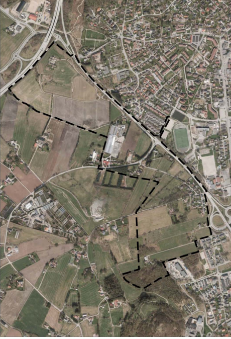
The detailed area plan for Jåttå Nord was accepted by Stavanger municipality in 2014 and entails the developed of between 800 and 1050 new houses, a sports/ recreation field, care home for sick and elderly, a kindergarten, food stores along with different service centres and religious houses. The development of the former agricultural area into one with housing and other physical infrastructure will increase the amount of impenetrable surfaces significantly, which place challenges for the area’s water and drainage system. The area is situated slightly downstream other agricultural areas and the gradient means that excess water will be transported to Jåttå Nord in the event of flooding. The existing water and drainage system transport run-off water and waste water (from households) in the same pipes and is not dimensioned to handle more run-off water than it does today. The necessity to handle run-off water therefore became a premise for the planning process. Climate change projections for the region include more precipitation.
Type(s) of the problem:
Water management
The Solution
The work with the detailed area plan for Jåttå Nord began in 2012. It was decided in the municipal board for urban development that the development of Jåttå Nord should not increase run-off water to the current water and drainage system.
Municipal planners and consultancy firms suggested that this could be achieved through a localised form of run-off water management. This included planning for more green areas (with greater infiltration capacity) and building a water storage facility (that could retain water during flood events). Consultancy firms assisted the local risk and vulnerability assessment, which focused specifically on run-off water. The detailed plan then went back and forth different municipal authorities, political boards and developers for revisions and hearing.
The resulting plan in 2014 entailed designated green structures meant to function as a form of rain gutters that retain run-off water and prevent flooding to meander from the upstream agricultural area. An underground basin as well as several football fields that can be flooded and absorb water during flood events also form part of this green infrastructure.
The Rogaland County reviewed the plan and supported the green structure idea and was against the idea of more densely used. For local politicians’ denser housing development and to use the available space for building purposes were since as more beneficial, since the housing situation is pressing within the municipality and the population is expected to increase. ‘
Researchers were in contact with planners and other personnel engaged in Stavanger municipality for the duration of the project. Planners were interested to learn how to dimension and calculate the amount of run-off water in a future climate with more precipitation. Natural scientists at the Bjerkens Centre, specialised in climate systems assessed the standard used by Rogaland County and Stavanger municipality. Researchers at the Western Norway Research Institute also urged the municipality to reconsider their current standard and also include the upper climate scenarios rather than the medium ones used by the planners. The upper climate scenarios put forward around 25% more autumn and spring precipitation (influencing the amount of run-off water)than the standard used during the reference period 1960-1990.
The planners concluded that an increased water and drainage capacity that could accommodate the upper climate change scenarios would be costly and involve technical difficulties. Some extra capacity to handle water exist within the water and drainage system, and the planners decided that this should be used for handling climate change instead of connecting new housing areas (with associated run-off water) to the existing system. This placed further demands on localised run-off water solutions when building new or developing existing housing areas.
Another important factor is that the municipality revised the overarching municipal spatial area plan. The revised plan now requires that run-off water management and alternative flood ways are included in detailed area plans. In addition, the overarching plan also stipulates that sufficient infiltration (soil and vegetation covered surfaces) areas should be put aside for run-off water. It is recommended that communal outdoor areas (playing grounds, sport fields) should be secured as run-off water surfaces . The plan for Jåttå Nord was conceived as a pilot project to test how these overarching goals could be put to practice and be used in a systematic manner.
Open run-off water solutions can improve water quality, contribute to biological diversity as well as ameliorate the recreation value of local housing areas. It can therefore be seen as a combination of technology and ecosystem based management with benefits exceeding adaptation to climate change and preventing risks of flooding.
While this adaptation measure have clear and multiple benefits it is a costly and politically challenging solution to implement since available areas for housing are scarce and local politicians and developers typically want to construct denser housing areas. Political demands of housing construction and denser utilisation of existing spatial area place demands and challenges on open water run-off solutions and the benefits this kind of green infrastructure can have for biological diversity, water quality and local environment. Since most of Stavanger’s municipality spatial areas already are developed, new construction will take place by cooperation with neighbouring municipalities and making urban areas denser. Even if the planning guidelines encourage the use of open small-scale ponds that can contain run-off water it is not likely that this will be used extensively in Jåttå Nord, due to the political demands to use more of the available are for housing.
Type(s) of the solution:
Market/Management-based solution
Technology-based solution
The Lessons
Specific attention to the risk of run-off water and increased precipitation predicted by climate change was brought into the planning process by the Stavanger municipality, the involvement of researchers, active overarching administrative level- the County of Rogaland. The Jåttå Nord planning process shows that challenges associated with current natural events and climate change can be dealt with locally. Solutions such as green structures (designated as infiltration surface areas) and open ponds can take off pressure from existing physical infrastructure such as water and drainage systems and probably reduce the risk of damage to buildings and other constructions. In addition, such solutions can be beneficial for local well-being, water quality and biodiversity. The lessons from Stavanger’s municipality highlights that planners need to have a clear focus on issues when developing new housing areas. Solutions that need space that could be used for housing construction will be costly as the area would be more profitable as housing rather than green structures (from the perspectives of politicians and housing developers). The overall AREALKLIM’s conclusions also point to the need to:
- Ensure the use of local knowledge in risk and vulnerability analysis (which Norwegian municipalities are legally obliged to conduct).
- Ensure that flood, slush (waterfilled snow) and landslide risk are covered in the analysis.
Most important lessons is that municipalities need to prevent natural hazards in today’s climate:
- To set aside sufficient administrative capacity to undertake local risk and vulnerability assessments and conduct spatial planning.
- To ensure that the municipalities have sufficient competency in conducting to undertake local risk and vulnerability assessments and conduct spatial planning.
- If needed, to search and find relevant knowledge outside the municipality, locally and/or from external institutions.
- That politicians should not accept a too high risk for natural hazards to satisfy local demands for development.
Contact
E-mail: